
Photographer Francis Haar documented parts of Chinatown and Pālama—known as ‘A‘ala in the 1960s—while they were being demolished, capturing some of the final images of a Honolulu that has since disappeared.
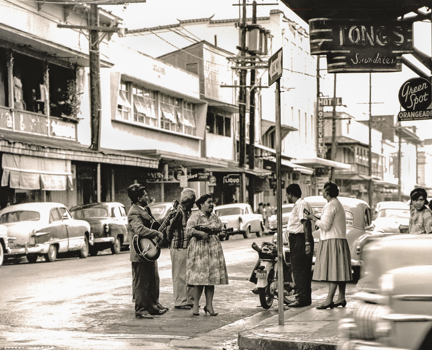
A Foremost milk carton. A wrecking ball. A woman wearing a mu‘umu‘u and slippers. A demolition claw obliterating a building. Signs for the Glory Inn, Uptown Cafe, and Paradise Pool Room. Shards of wood piled up by structures getting razed. Families washing dishes on the lānai surrounding a tenement. The exposed edge of a stone building being torn down. People standing in the streets strumming ‘ukulele and a guitar.
These stark images photographed by Francis Haar are of a Honolulu disappearing. He shot them in the 1960s at the convergence of Chinatown and Pālama along Nu‘uanu Stream, though they could have been taken in Kaka‘ako or Mō‘ili‘ili in 2019.
Haar used a medium-format camera, a Mamiya C33 twin-lens reflex, which allowed for intimacy with the subject. (The viewfinder is on top of the camera, so the lenses are at his waist.) While he focused on the spaces that were about to be destroyed, he also looked at the people who frequented them, documenting the neighborhood’s humanity. Images show kids running on a lānai, a man leaning on a car while smoking a cigar, a woman with a sly smile crossing the street.
Haar, was born in 1908 in Hungary and lived in Paris, Tokyo, and Chicago before moving to Honolulu in 1960 with his wife, Irene, who was also a photographer, subject, and assistant. He became interested in ‘A‘ala while working as a photography professor at the University of Hawai‘i at Mānoa when Kenneth Bushnell, a friend and painter who had a studio in the neighborhood, told him it was going to be razed.
Haar captured more than 300 pictures in ‘A‘ala and the surrounding area while it was torn down, and he collaborated with Bushnell and writer Stephen Bartlett to make a documentary titled Aala — Life and Death of a Community. The film and 40 of Haar’s photos are on display until December 6, 2019 at UH Mānoa’s John Young Museum of Art.

“Every picture that you have taken—that moment is gone,” said Gaye Chan, the UH art history professor who curated the show, titled Disappearing Honolulu. “What I love about seeing old photographs is not really nostalgia, but it allows my body to occupy a different time and space momentarily.”
Growing up on O‘ahu, my early memories of ‘A‘ala Park are from the 1990s, when Mayor Frank Fasi declared it a homeless “safe zone.” Then in 2002, an old roller-skating rink was renovated and turned into a skate park. In 2019, the city added a fenced dog park, and the 11-story, $100-million headquarters for American Savings Bank was completed across the street.
This block is a microcosm of what I have witnessed across Honolulu—everything changing around me as I change too. When I’m at the park, these memories are layered on top of the landscape, and it can be easy to assume this was the way it always was. But Haar’s photos capture a nearly forgotten history of a place I thought I knew.
Between 1900 and 1940, ‘A‘ala Triangle (now the northern half of the park) was the center of a bustling community of Japanese-owned markets, movie theatres, dance halls, and hotels. Commonly known today as Pālama, ‘A‘ala came to be called Japantown as many Japanese immigrants moved off plantations into the area. But the neighborhood began to struggle in 1941 with World War II, when some of the business owners and community leaders were sent to internment camps, forcing shops and social clubs to shutter.

The region evolved as U.S. military personnel frequented the area, demanding bars, billiard rooms, and brothels. After the war, some Chinese and Japanese residents left, and single plantation workers, often Filipino men, came to hang out. By the 1950s, ‘A‘ala and neighboring Chinatown were densely populated, multi-cultural residential and commercial neighborhoods.
Then, in the ’60s, the Honolulu Redevelopment Agency used federal grants to clear more than 150 acres between School and King streets. Most of ‘A‘ala and parts of Chinatown were condemned as slums with their decaying single-occupancy apartments and makeshift homes, many of which had been built before plumbing and fire codes.
It won’t be long before the last people who grew up shopping or living in the old ‘A‘ala will be gone, along with their memories of this time and place. While Waikīkī’s fancy hotels and idyllic beaches are featured on postcards of the era, Haar aimed his camera at unconventional details, capturing what Hawai‘i was like for many hard-working locals. We often think of our cement city as an immutable monolith, but its layered history runs the risk of being forgotten without photographers like Haar.

Though he focused on the architectural character of the city’s buildings, Haar gave special attention to the people inhabiting them. In 1963, Haar first exhibited these photos at George Hall, the former home to the Department of Art, at the University of Hawaiʻi at Mānoa.


